Insights into Busan Port
Geographical Characteristics and Significance
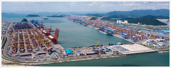
Busan Port, situated at the southeastern tip of the Korean Peninsula (35°04′42"N, 129°01′01"E), serves as a vital gateway connecting the Pacific Ocean and Eurasia. It is Korea’s largest facility of its kind, ranking 7th among container ports worldwide (as of 2023). Encircled by mountains and islets, the port benefits from calm inner waters and a minimal tidal range. Its position along three major global arterial sea routes provides exceptionally favorable conditions for navigational efficiency and logistics functionality.
Port facilities: Capacity & Development Progress
Opened in 1876 under the name Busanpo, Busan Port has evolved into Korea’s premier maritime hub through relentless expansion since the time the first pier was built in 1906.
Today, the port boasts 42.9 kilometers of quay walls, accommodating up to 212 vessels at once, and can handle over 410 million tonnes of cargo annually. To keep pace with rising container demand, Busan New Port, with a planned 53 berths and an operational capability of 35 million TEUs per year, is slated for full completion in 2037.
Busan New Port Project
- Location: Northern coastline of Gadeokdo Island in Gangseo-gu, Busan Metropolitan City; Yongwon, Ungdong, and Jedeokman Bay in Jinhae-gu, Changwon
- Period: 1995 – 2037
- Estimated Budget: 18.3 trillion won
-
Core Components
- (Government) 2 multipurpose piers, 0.8 km small-vessel pier, 6.09 km breakwater, 33 km revetment, 56.15 km of roads, 54 km railway, Todo Island removal, dredging, 8.29 million m² hinterland development
- (Private Investment) 53 container berths, 4 general cargo piers, 15.26 km of roads, 1 LNG bunkering base, 1 ship repair yard, etc.