Attraction providing a glimpse into Lower Dadaepo Formation deposited during the late Cretaceous period, about 80 million years ago, and the crustal deformation process in the Busan area after that.
Superb attraction to appreciate a diversity of rocks along the seashore, including sedimentary rocks of Dadaepo Formation, ignimbrite created by volcanic activity, basalt made by flowing lava and rhyolite interpenetrating the basalt, against the backdrop of beautiful coastal views.
It offers trail courses from Songdo Beach to Amnam Park for appreciating the unique and diverse geological records of dinosaur skeleton and egg nest fossils, calcic paleosoil, dikes, veins, faults, ripple marks and reduction spots.
Introduce
Along the shore, various rocks, such as sedimentary rocks of Dadaepo Formation, basalt, pyroclastic rocks, and intrusive rhyolite are exposed with dinosaur bones, egg nest fossils, and calcic paleosols. You can enjoy the various geologic records with the marvelous landscape of Hallyeohaesang.
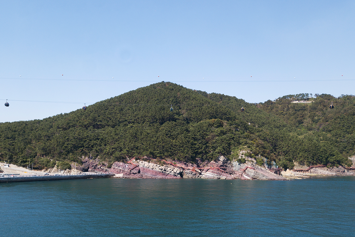
Dudo is an inhabited island showing magnificent sceneries of volcanic rocks and Lower Dadaepo Formation from Late Cretaceous that is sitted along the sea cliffs of south Songdo Peninsula. It is a treasure box of dinosaur bones and egg nest fossils.
Origin of its name
“Songdo” refers to the present 「Turtle Island」. Although it is a small, low-lying island in the range connected from Songnim Park, it was called Songdo because pine trees naturally grow on the island just like 「Dudo Island」 located at the tip of Janggunsan Mountain on the opposite side. During the Japanese colonial era, Japanese dwellers established Songdo-based Songdo Yuwon Co., Ltd.(Jul. 1913) and installed a service area called「Sujeong(pavilion on water)」, destroying the true nature of Songdo which was reduced to its turtle-shaped rock form.
Even now, the bygone contour of Turtle Island can be identified with rocks remaining in the perimeter of the island. But when the Japanese built Sujeong and developed a bathing resort using an extensive sandy beach, the beach with gentle waves, shallow waters and the surrounding pine forest became a national attraction. Now, its bygone scenery has disappeared and the pine forest and sandy beach have lost the past vestige of the island in the name of development, with only its name remaining.
Name and history
Songdo Peninsula is a long and narrow peninsula between Songdo Beach and Gamcheon Port with Amnam Park at the tip. Songdo of Songdo Peninsula refers to the present「Turtle Island」 located in waters off Songdo Beach. The island was called Songdo due to its native pine trees. During the Japanese colonial era, Japanese dwellers established Songdo-based Songdo Yuwon Co., Ltd.(Jul. 1913) and installed a service area called「Sujeong(pavilion on water)」, destroying the true nature of Songdo and leaving only a turtle-shaped rock behind.
Tourist information
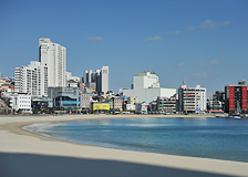
Songdo Beach (the Naples of the East)
Korea’s first beach
Songdo Beach Ground Fountain 1, 2: operated at 11a.m./2p.m./5p.m./7p.m. for 30 minutes each time (when the beach is open)
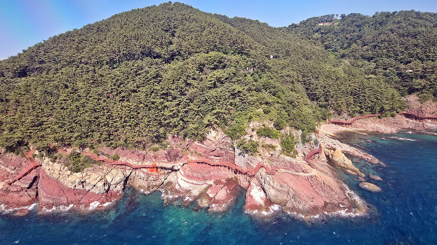
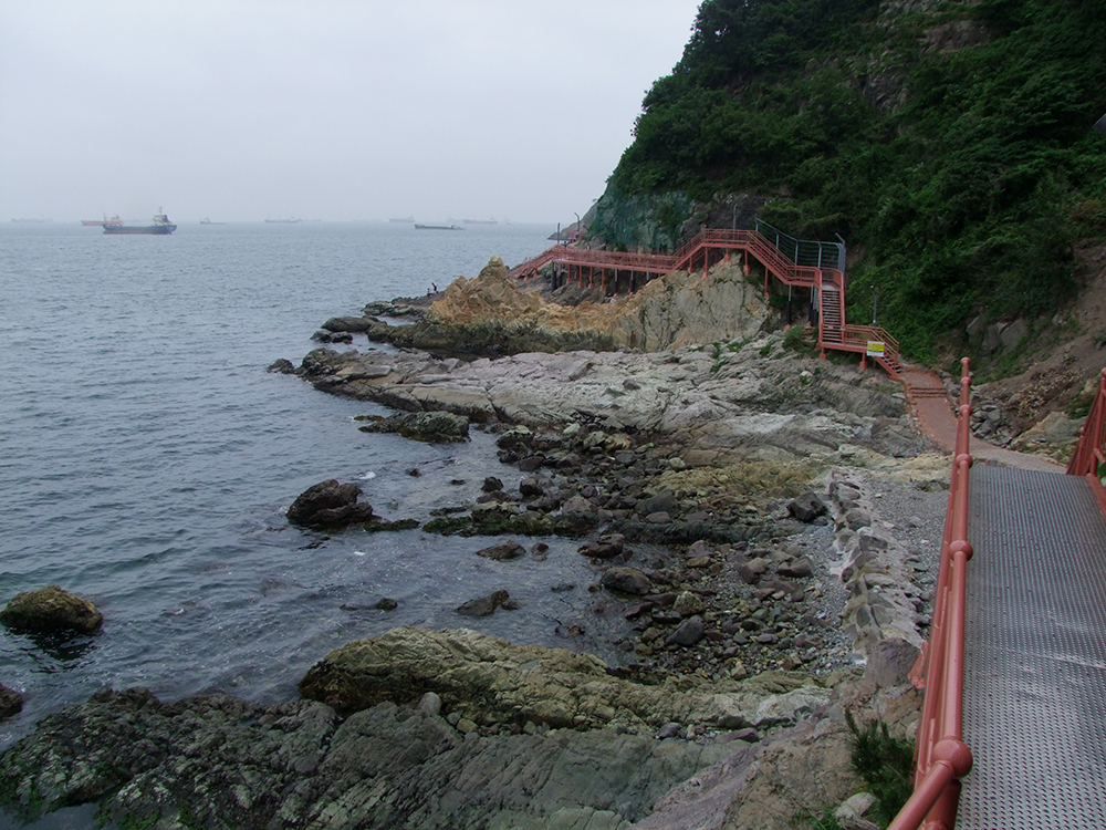
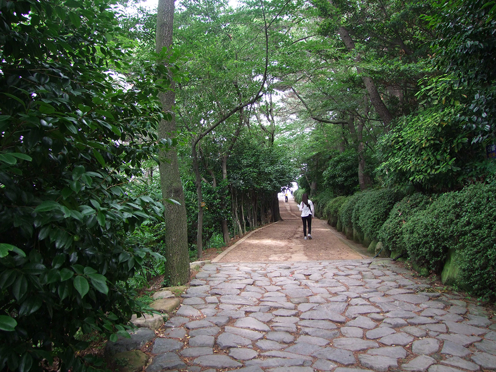
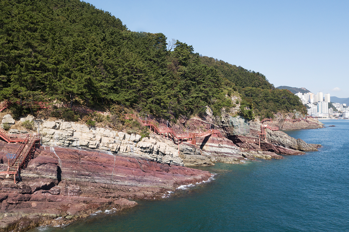
Songdo Coastal Walkway (0.8km, average 20 minutes)
Connecting Songdo Beach and Amnam Park
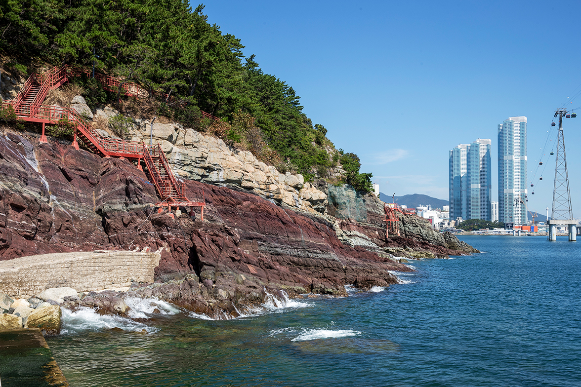
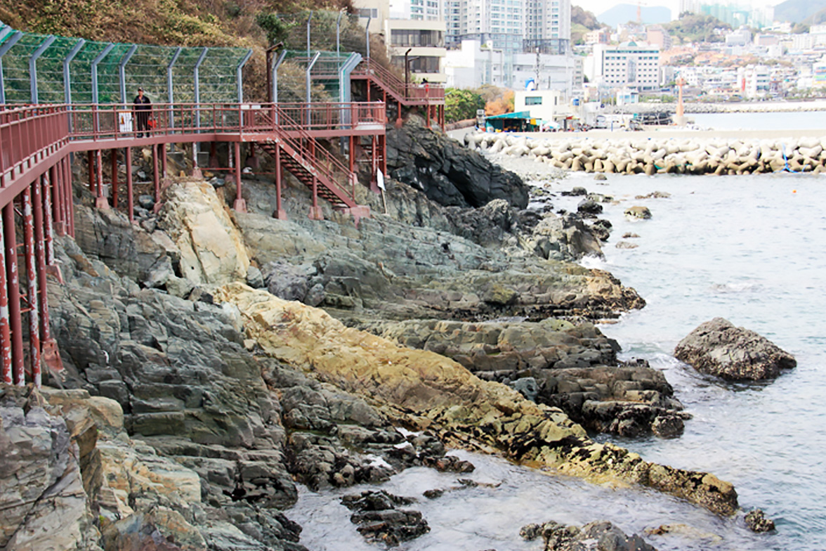
Appreciate beautiful Songdo coast with numerous ships at anchor against the backdrop of a beautiful Amnam Park, formed by sedimentary rocks traced back 100 million years.
Three observation platforms offer views beyond the horizon of the South Sea, with fun swing bridges and fishing places scattered below the walkway.
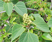
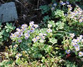
Representative vegetation
Idesia
Idesia, a deciduous tree belonging to the Flacourtiacea genus, grows well in forests on the seashore. Male and female trees grow separately and are used as street or garden trees due to their beautiful bark and big leaves.
Aster spathulifolius
Aster spathulifolius, a perennial herb belonging to chrysanthemum family, grows in cracks in seashore rocks or mountains and is a common sight on the seashore in Busan. Violet flowers blooming in clusters in the autumn are a beautiful sight.
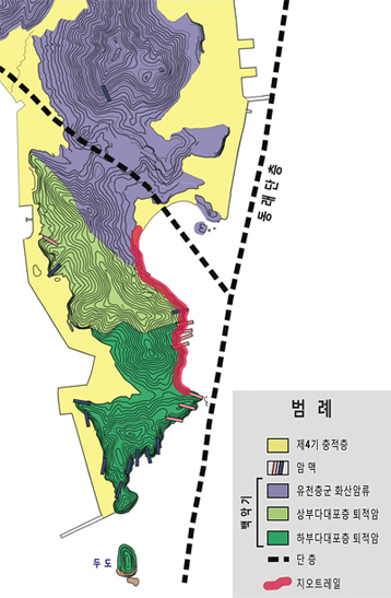
Geological features of Songdo
A big lake referred to as Dadaepo Basin was formed in the area ranging from Dadaepo of Nakdonggang Estuary to Songdo during the late Cretaceous period of the Mesozoic Era (about 8-70 million years ago).
There are big faults called Dongnae Fault in the east of Dadaepo Basin and Yangsan Fault in the west. These faults moved and crustal plates spread apart in the late Cretaceous period, forming Dadaepo Basin.
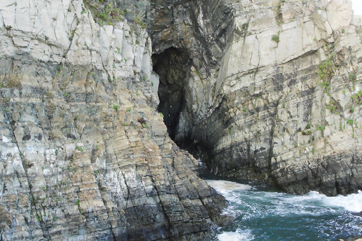
Thick sedimentary layers were deposited when a large lake called Dadaepo Basin was formed and were named Dadaepo Formation by geologists. Dadaepo Formation is divided into Upper and Lower sections based on the features of its component rocks(presence of red layers and content of volcanic substances) and differences of sedimentary environments. With andesitic volcanic rocks called Yucheon Group in its lower section, Dadaepo Formation covers these volcanic rocks with the uncomformity surface. This uncomformity surface is observed on Dusong Peninsula and the Dudo area west and south of Songdo Peninsula.
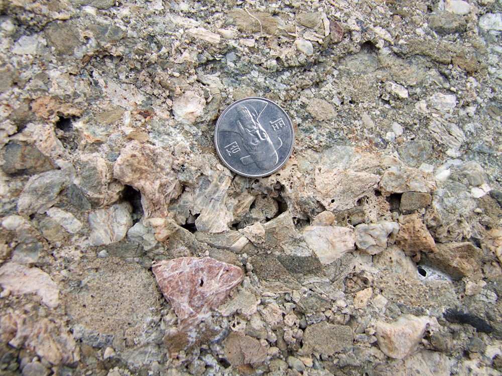
Lower Dadaepo Formation is comprised of relatively pure non-volcanic sediments of alternating red mudstone, siltstone, sandstone and marl. Five or more conglomerate sheets 1-5m thick appear with various component gravels of chert, quartzite, volcanic and sedimentary rock. Red layers are characterized by unique geological records of calcic paleosols, dinosaur skeleton fossils, dinosaur egg nest fossils, silicified wood fragments and reduction spots.
Upper Dadaepo Formation is mainly comprised of dark grey and grayish-green tuffaceous sandstone including tuffaceous conglomerate, coarse-grained sandstone, siltstone and tuff, characterized by a high volcanic substance content. Tuffaceous sandstone with well-developed cross bedding includes volcanic rock fragments of various types and sizes. Balstic sills and dacitic tuff appear between Upper Dadaepo Formation strata. Such characteristics mean volcanoes were active in the area during sedimentation of Upper Dadaepo Formation.
The top of Upper Dadaepo Formation is covered in thick andesitic pyroclastic rock and lava flows corresponding to Yucheon Group volcanic rock type.
The center provides information on geological attractions and geotrails of Songdo Peninsula and is located at the entrance to Songdo Peninsula Coastal Walkway. Busan Geopark and Songdo Peninsula trail leaflets will help you understand the geological attractions.
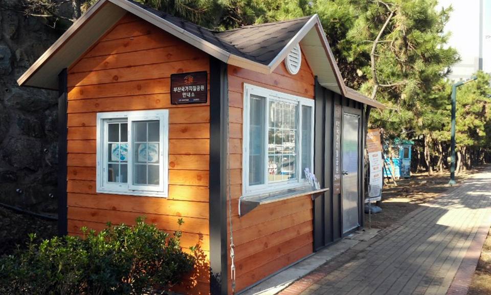
S1.Outdoor Rocks and Minerals Exhibition Center
Outdoor rocks and minerals exhibition center built at the entrance to Songdo Peninsula walkway, displays 34 pieces of various igneous, sedimentary and metamorphic rock; 15 pieces of rock-forming minerals, metallic minerals, sulfide minerals and ore minerals; and 24 pieces of geological structure and fossils. With brief information on chemical formulae, usage and producing area of each rock and mineral provided, students can use it as a rock and mineral learning center for field trips.
S2.Basalt lava
In a large lake called Dadaepo Basin, formed in remote antiquity by crustal plates spreading apart around the Songdo area during the late Cretaceous period of the Mesozoic Era, sedimentary layers called Dadaepo Formation were being stacked. Then, one day, a volcano erupted around the lake sending basalt lava flowing into the lake and covering the top of the Formation, leaving geological records behind in this place. As a result of radioactive isotope-based age dating the basalt, it was found to have happed about 70 million years ago.
The boundary between the basalt and Dadaepo Formation is bumpy and the basalt reveals the typical characteristics of lava such as porphyritic and porous textures and auto-brecciated rock fragments.
S3.Tuffaceous sedimentary rock of Upper Dadaepo Formation
Basin-shaped Dadaepo Basin was formed by crustal plates spreading apart in the Songdo Peninsula area about 7~80 million years ago, with sedimentary layers called Dadaepo Formation being deposited in the basin. In the beginning, the flowing river often flooded and Lower Dadaepo Formation was deposited in the basin, which then deepened to change into a lake where Upper Dadaepo Formation was deposited. Around the lake, volcanic substances that got into the lake due to intense volcanic activity built up together with Upper Dadaepo Formation. The typical characteristics of Upper Dadaepo Formation can be observed in this place.
Upper Dadaepo Formation comprises mostly tuffaceous sedimentary rock with a high content of volcanic substances, and preserves the sedimentary structure including bedding, cross-bedding, ripple marks and cut-and-fill structure, also including numerous fragments from volcanic rocks created by volcanic activity that occurred around the lake. Between Upper Dadaepo Formation strata, ignimbrite appears, a result of sedimentation of pyroclastic flow created by explosive volcanic eruptions.
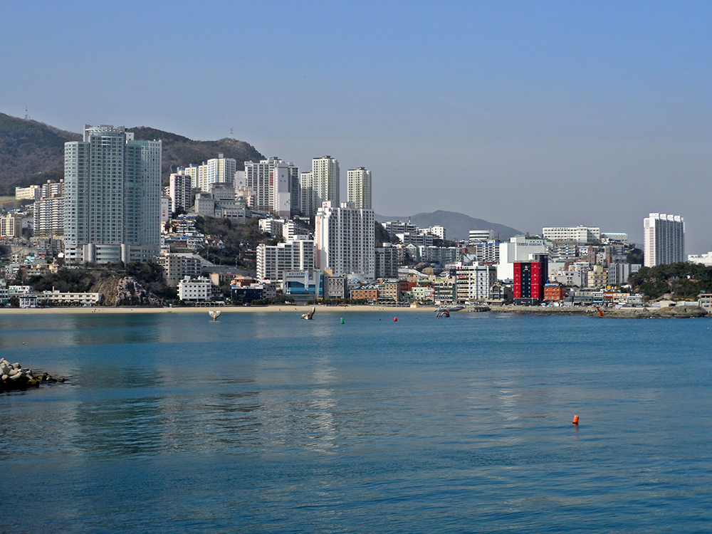
S4.View of Songdo Beach
Vantage point for viewing superb scenery of Songdo Beach and its surroundings. The sandy beach of Songdo Beach, Namhangdaegyo Bridge behind it, Yeongdo, downtown Nampo-dong, the sea off Busan Bay and ships at anchor. These elements combine in harmony to create a magnificent view. Songdo Beach was Korea’ first beach to open(1913). The sandy beach was enlarged, with fountains and sculptures installed, transforming into a beach park through recent development. Raw fish centers concentrated around the beach offers sliced raw fish, Busan’s signature specialty. Trail courses provide photo zones for taking great pictures against the backdrop Songdo Beach’s beautiful surroundings.
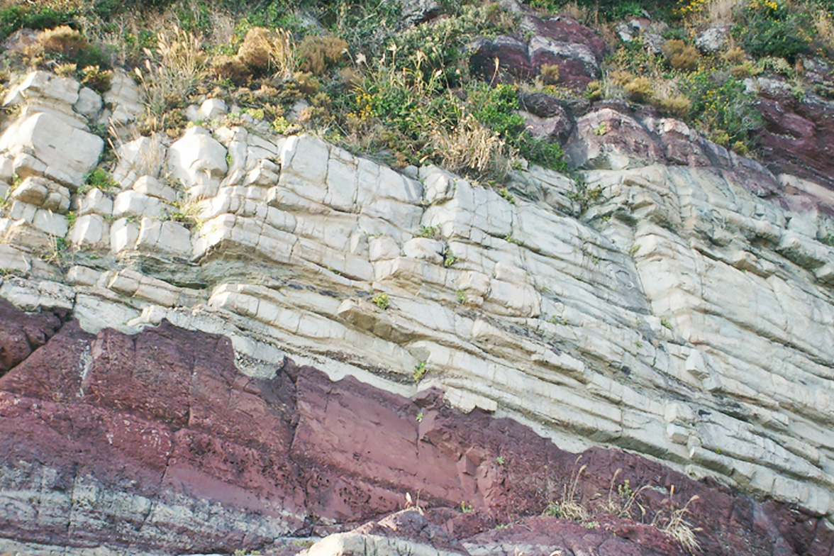
S5.Ignimbrite
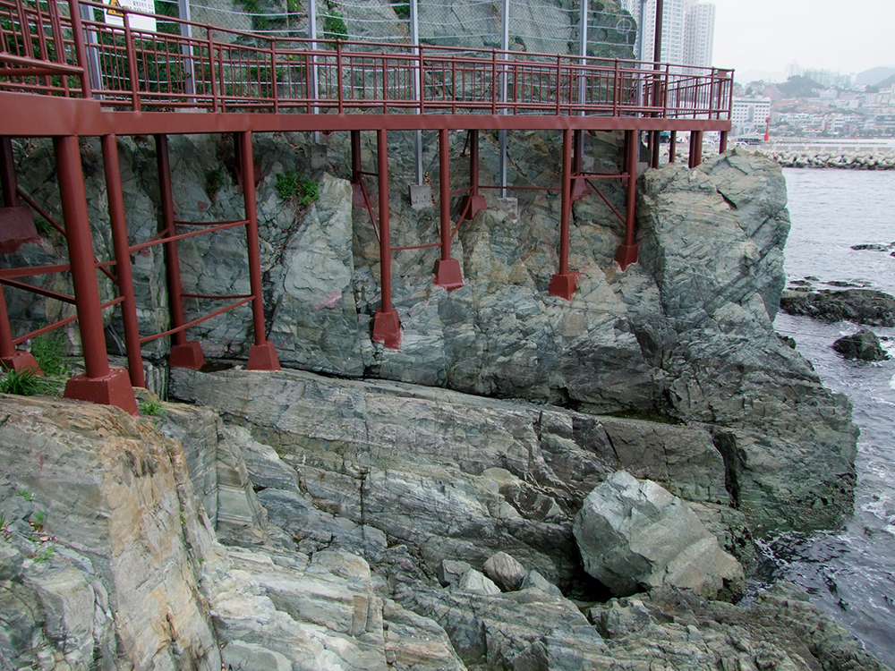
At the S5 point, the dark grey tuffaceous sedimentary rock section that continues from the S1 point ends and the red strata begins. Because the features of strata abruptly change, geologists made a division here into Lower Dadaepo Formation, which is the lower section of the strata, and Upper Dadaepo Formation, the upper section. They attribute changes in the strata to changes in the environment(from river to lake) where strata were stacked. Unusually, unique red strata with many white feldspar crystals appear on the boundary of Lower and Upper Dadaepo Formations. These strata are ignimbrite, piles made by pyroclastic flow created by intense volcanic eruptions that reached the lake. This ignimbrite is good evidence of invigorated volcanic activity around the lake when Upper Dadaepo Formation was formed. Geologists assume that the reason why the sedimentation environment suddenly changed to the deep lake was related to volcanic activity.
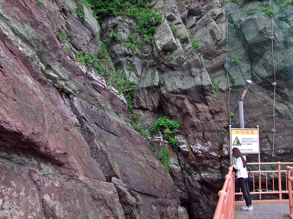
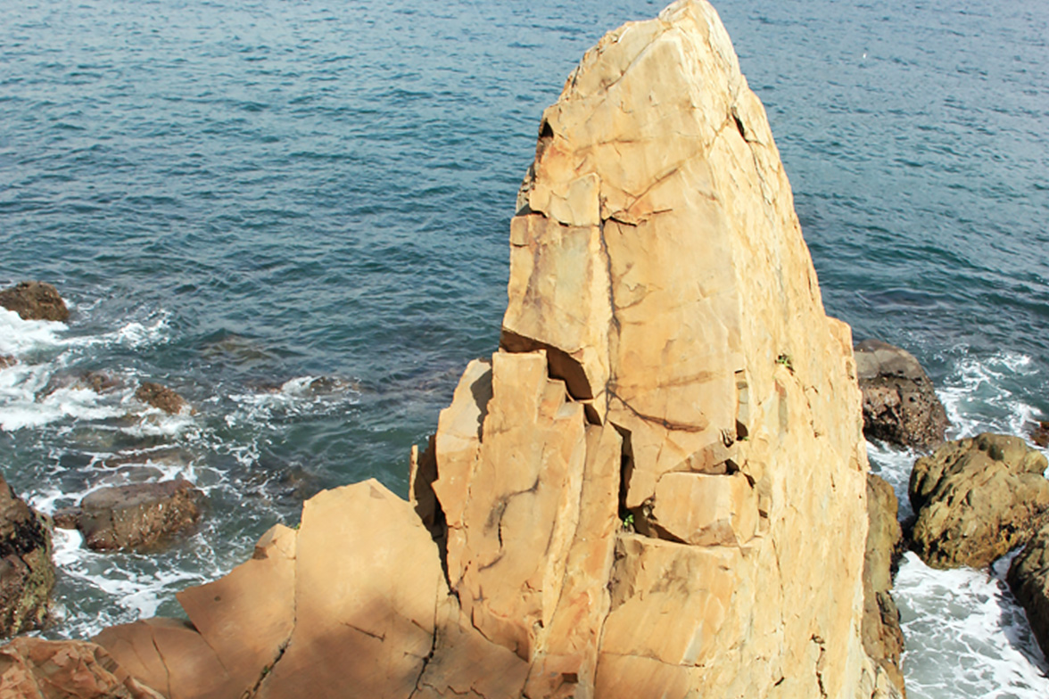
S8.Rhyolitic dike swarm
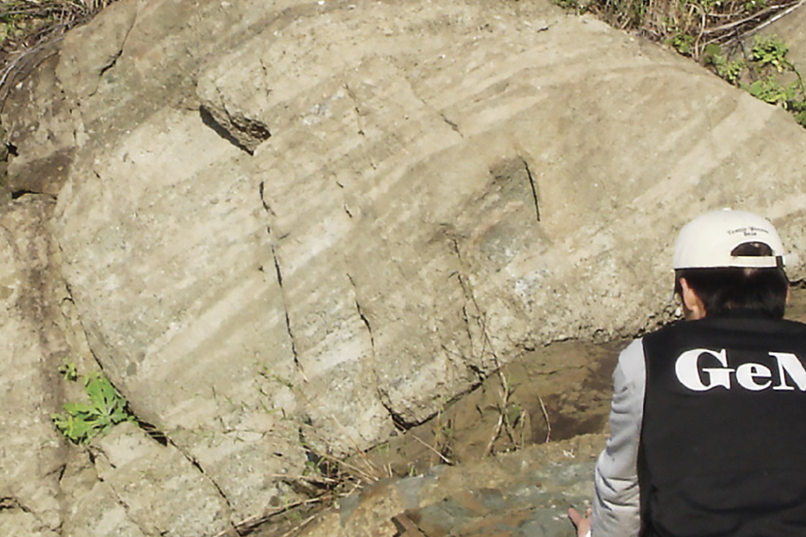
During a stroll along the sedimentary rocks with flat bedding developed like stacked wooden boards on the Songdo Peninsula trail course, many long bright yellow-hued bodies cutting the bedding of sedimentary rocks can be seen. Such bodies were created by magma’s interpenetration along joints (cracks) developed in sedimentary layers. Such a structure is called a dike. Bright colored dikes on Songdo Peninsula corresponding to rhyolitic dikes that were interpenetrated by rhyolitic magma. At the S8 point, three rhyolitic dikes in almost similar directions can be observed together. Interpentration of several dikes in such systematic directions is called a dike swarm.
Rhyolitic dikes are more resistant to erosion by waves and weathering than surrounding sedimentary rock, and they protrude in bizarre shapes.
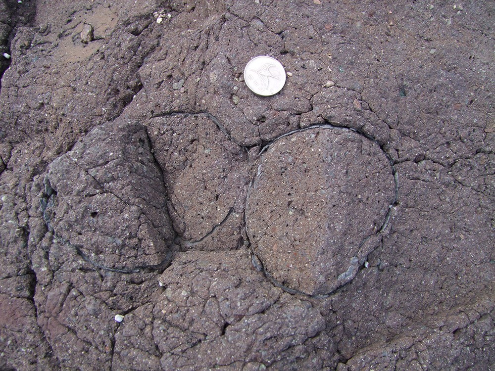
S9.Dinosaur nest fossil
The time when Lower Dadaepo Formation in red was deposited on Songdo Peninsula was during the late Cretaceous period of the Mesozoic Era, which was the time of dinosaur’s paradise. Dinosaurs resided around the rivers and lakes where sedimentary layers were being formed, laying eggs in their habitat. Traces of dinosaur life such as footprints, eggs and bone fossils can be found in the Lower Dadaepo Formation. Recently, the area’s dinosaur egg nest fossils with several dinosaur eggs gathered on red sandstone and siltstone have been gaining attention in geological circles. Dinosaur eggs discovered here are about 10cm long in a well-preserved oval shape. Ten eggs have been discovered and geologists’ studies are in full swing to find out the species of dinosaur that laid the eggs.
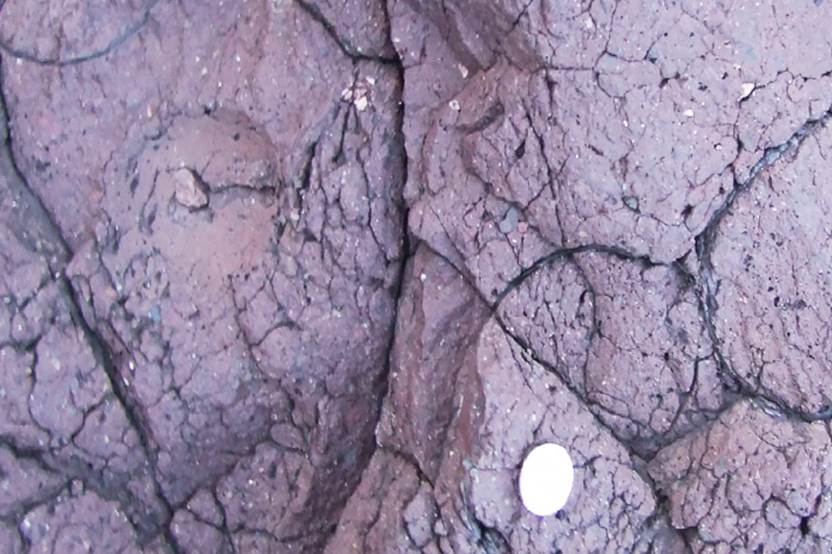
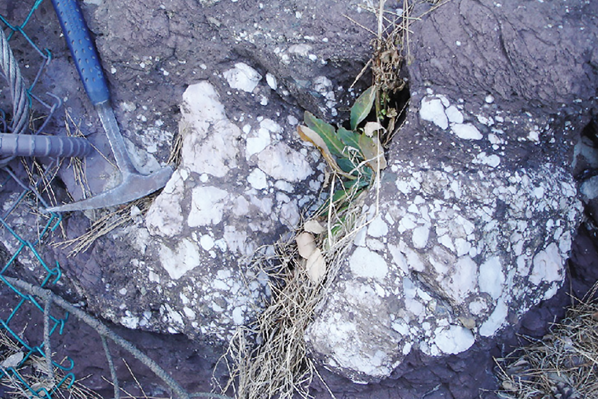
S10.Calcic paleosols (Calcrete)
The red strata of Lower Dadaepo Formation contain many white nodules. These are calcrete made up of calcium-rich calcic substances. When dilute hydrochloric acid is sprayed on them, they react violently with bubbles. Concentrated calcic nodules form paleosols or come out in calcrete intraclast layer form. Various types of nodular, layered and spilling calcrete are very rare, therefore they have high geological value. Further, because calcic paleosols provide information on the weather in the Busan area during the late Cretaceous period, they have high research value.
S11.Normal fault
The strata of red sandstone, siltstone, grey conglomerate and calcic paleosols deposited in sequence continue and then a fault - a break on the strata - appears out of nowhere. This fault reveals the form of normal faults whereby the upper block moves downwards from the lower block and several small scale faults appear around a major fault caused by the largest scale movement. Because Dadaepo Basin where Dadaepo Formation was deposited was formed by the crust spread apart due to the tension(tensile force) of the crust, many normal faults made by tensile force are observed in Dadaepo Formation. Geologists measure the direction of normal faults to find out the force the crust received during the late Cretaceous period when Dadaepo Formation was deposited. They are studying how the crust was spreading apart to make a big lake called Dadaepo Basin and the subsequent Dadaepo Formation.
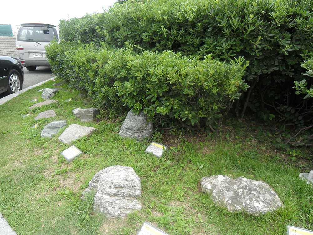
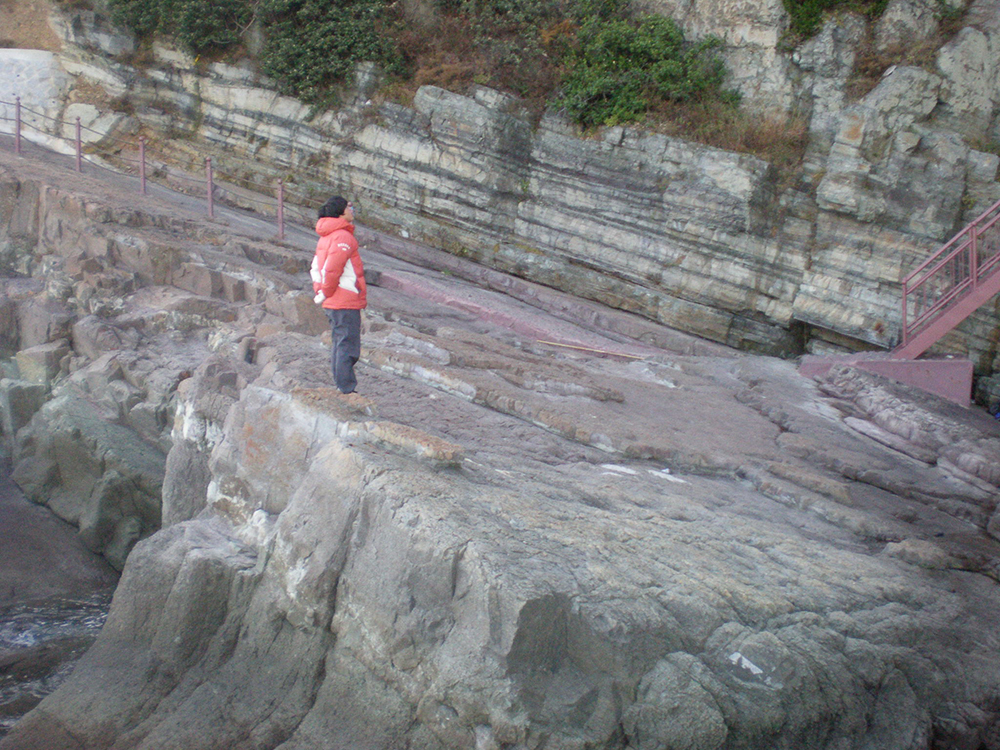
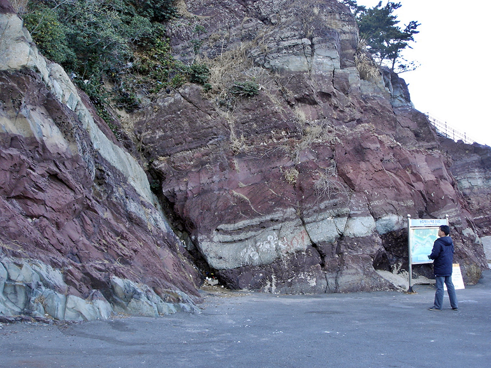
S12.Lower Dadaepo Formation
Dadaepo Basin was formed due to the crust spreading apart in the Songdo Peninsula area about 7~80 million years ago and sedimentary layers called Dadaepo Formation were deposited. In the beginning, the flowing river often flooded, depositing Lower Dadaepo Formation in the basin. The basin then deepened and changed into a lake, where Upper Dadaepo Formation was deposited. In this place, Lower Dadaepo Formation is well exposed along the coastal cliffs. Lower Dadaepo Formation, the lower section shows red sandstone – a stack of sediments transported from the periodically inundating river -, siltstone and grey conglomerate alternately. Unlike volcanic substance-rich Upper Dadaepo Formation, it shows the feature of a lower volcanic substance content. On red strata, various geological records including reduction spots, bioturbation structure and calcrete can be observed with interesting geological records of chert clasts, crossbedding and cut-and-fill structure on conglomerate.
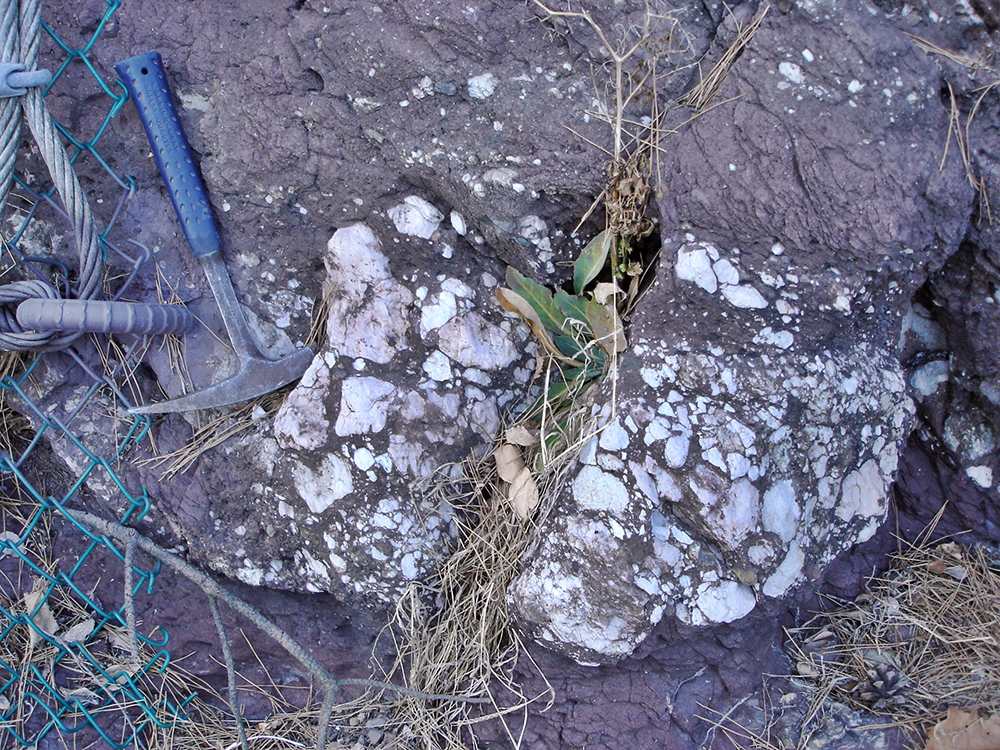
S13.Conglomerate
In this place, thick conglomerate developed on Lower Dadaepo Formation can be observed. It is known that 6~8 conglomerate sheets deposited during the inundation of the river appear on Lower Dadaepo Formation. Conglomerate contains various types of rock fragments in various shapes and sizes. Characteristically, conglomerate contains many beautiful colored chert fragments.
S14.Amnam Park
It was designated as a natural park in 1972, but then redesignated as a military reservation so access to the park was restricted. It reopened in 1996. The entire park comprises dense forests of oceanic trees with colonies of natural eco-systems rare in cities, including 500 species of marine plants and wildflowers. Oddly shaped precipitous cliffs soar along the coast, providing a fantastic view against the blue sea.
Equipped with the infrastructure of observation platforms, suspension bridges, a square, sports facilities and fishing facilities, you can enjoy forest bathing with dense pine trees along the walkway from the entrance. With rock sculptures displayed all over the park, New Stone Age relics including Comb-pattern Pottery and shell mounds have been excavated in the park. The local government is planning to use the park as a space for ecology education by building a nature learning center.
Songdo Beach boasting beautiful coastline was Korea’s first beach and is now a beach park with dazzling white sand and a gorgeous fountain and green space, offering four-season entertainment. Songdo’s summer overflows with colorful streams of youth and romance with scorching sun and blue waves and its nighttime landscape lighting up Songdo nights to create a fancy and fantastic beach atmosphere.
051) 240-4781
Take exit 2 of Jagalchi Station on Metro line 1 and transfer to bus.
Bus No. 26, 30 and 96 → Get off at “Songdo Beach.”
Bus No. 61 → Get off at “Songdo entrance.”
Directions
Privately-owned car/ rental car
For using Gyeongbu Highway
Guseo IC – Beonyeong-ro – Pier – Busan Main Customs - Busandaegyo Bridge – Namhangdaegyo Bridge – Songdo
For using Dae-Busan Expressway
Samnak IC – Baegyang Tunnel – Sujeong Tunnel – Busan Main Customs - Busandaegyo Bridge – Namhangdaegyo Bridge - Songdo
※ Enter Songdo Beach or Amnam Park into your navigation system
Bus
When arriving at Nopo-dong terminal
Nopo-dong Station on Metro line 1 – Get off at Jagalchi Station – Transfer to bus No. 7 (Take exit 1) or bus No. 30 or 96(exit 2) after crossing the road.
When arriving at Seobu Intercity Bus Terminal
Sasang Station on Metro line 2 – Transfer to Line 1 at Seomyeon Station – Get off at Jagalchi Station – Transfer to bus No. 7 (Take exit 1 of Jagalchi Station) or bus No. 30 or 96 (Take exit 2 of Jagalchi Station) after crossing the road – Get off at Songdo Beach
Train
When arriving at Busan Railway Station
Busan Station on Metro line 1 – Get off at Jagalchi Station – Transfer to bus No. 7 (Take exit 1 of Jagalchi Station) or bus No. 30 or 96 (Take exit 2 of Jagalchi Station) after crossing the road – Get off at Songdo Beach
Festival information
Information festivals around attractions
*Please move left and right to check the contents.
Festival name
Hosting month
Location
Official contact No.
Songdo Full Moon Festival
Jan. 15 in lular calendar
Songdo Beach
051-240-4065
Busan Sea Festival
August
Songdo Beach
051-501-6051
Gudeokgol Culture & Art Festival
September
around Kkonmaeul Village camping site
051-240-4781
Busan Mackerrel Festival
October
Songdo Beach
051-231-4085
Travel information
Tourist information centers nearby
*Please move left and right to check the contents.
Nearby Tourist Information Center
Information center
Official contact No.
Information center
Official contact No.
Busan Information Center
051-253-8253
Changseon Tourist Information Center
051-242-8253
International Tourist Terminal Tourist Information Center
051-465-3471
Taejongdae Tourist Center
051-860-7866
Busan Station Information Center
051-441-6565
Tourist attractions nearby
BIFF Plaza
Dadaepo Beach
Amisan Observatory
Bosu-dong Bookstore Alley
Jagalchi Market
Dadaepo Dreamy Sunset Fountain
Kkangtong Market
Amanm Park
Gukje Market
Nakdonggang Estuary Eco Center
Morundae
Nakdonggang Bird Sanctuary
Information on tourist attractions
Amnam Park
Amnam Park, surrounded by dense forests and offering magnificent natural views, is a natural park where you can enjoy forest bathing while taking in the sea along the coast. It is also the best urban park, gaining the spotlight for its oddly shaped precipitous cliffs. As a primeval natural park as well as city neighborhood park, it is home to colonies of natural eco-systems rare in cities, including sedimentary rocks formed roughly 100 million years ago, primeval forests, 100 species of wildflowers and 370 species of plants, characterized by native marine plants. It is an attraction frequented by numerous tourists and anglers, equipped with fishing areas, observation decks and walkways all around.
051) 240-4781
Take exit 1 of Nampo Station on Metro line 1 and transfer to bus.
Intra-city bus No. 7, 9, 9-1 and 71 → Get off at “Amnam Park”.
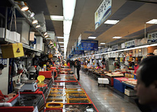
Jagalchi Market
Jaglchi Market, leading from dried fish shops below Yeongdodaegyo Bridge to Nambumin-dong Dawn Market, is considered synonymous with Busan; a symbol and a market best capturing Busan’s unique nature. The location of the current Jagalchi Market is the site for the former “Busan Seafood Processing Plant,” which was demolished in 2001. With a modern building, the market reopened in 2006 as an international fish market commensurate with Busan’s standing as a maritime city. Afterwards, Jagalchi Market cemented its position as Busan’s symbolic landmark, leading the revitalization of local commercial areas. As the world’s best seafood market, it has become the symbolic attraction meeting expected effects for international tourism.
Songdo beach road (Amnam-ro), Seo-gu
051)245-2594
Get off at Nampo or Jagalchi Station on Metro line 1.
Bus No. 61, 17, 134, 87, 26 and 103 → Get off at “Nampo-dong.”
Bus No. 27, 41, 5-1, 139 and 1003 → Get off at “Nampo-dong BIFF Plaza.” (bus returns from “Sindong-a Market”)